Jefferson night lights from space
Night Light of Jefferson (Georgia) from space (United States) Src. Average luminocity for 10x10km area is 34.9487% and for 50x50km: 29.3439%.
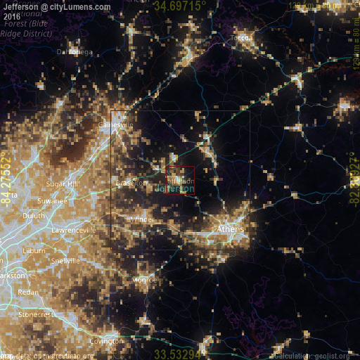
Analysis of Jefferson night lights 2016
Square area 10x10 km:
 1.65%
1.65%90-99
2.01%80-89
3.3%70-79
9.52%60-69
5.13%50-59
8.97%40-49
6.78%30-39
8.97%20-29
11.54%10-19
23.63%0-9
18.5%Square area 50x50 km:
2.6%90-99
2.65%80-89
3.27%70-79
5.68%60-69
5.41%50-59
5.52%40-49
5.96%30-39
7.66%20-29
8.8%10-19
15.81%0-9
36.64%Clear (daylight) street map image can be seen on geolist.org.
Map coordinates:
34° 41' 49.7" North, 84° 16' 31.9" West
34° 7' 1.4" North, 83° 34' 20.6" West
33° 31' 58.6" North, 82° 52' 9.4" West
Some cities around Jefferson sort by population:
• Athens
24.9 km =15.5 mi,  134°
134°
• Gainesville
30.7 km =19.1 mi,  310°
310°
• Winder
19.4 km =12.1 mi,  224°
224°
• Braselton
17.5 km =10.9 mi,  267°
267°
• Country Club Estates
20.7 km =12.9 mi, 133°
• Auburn
26.2 km =16.3 mi,  243°
243°
• Commerce
14.4 km =8.9 mi,  47°
47°
• Dacula
33.2 km =20.6 mi, 244°
4202672 (p: 10,195)
Sources (retrieved 2019-11-25):
» Earth at Night: Flat Maps 2012, 2016