Ionia night lights from space
Night Light of Ionia (Michigan) from space (United States) Src. Average luminocity for 10x10km area is 20.1048% and for 50x50km: 3.1235%.
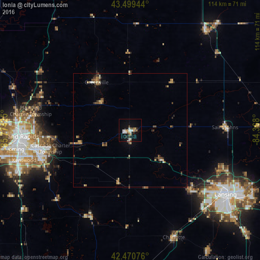
Analysis of Ionia night lights 2016
Square area 10x10 km:
 4.13%
4.13%90-99
3.97%80-89
2.22%70-79
0.95%60-69
2.06%50-59
1.59%40-49
1.75%30-39
2.38%20-29
1.75%10-19
19.52%0-9
59.68%Square area 50x50 km:
0.27%90-99
0.35%80-89
0.51%70-79
0.32%60-69
0.49%50-59
0.55%40-49
0.47%30-39
0.48%20-29
0.57%10-19
0.97%0-9
95.03%Clear (daylight) street map image can be seen on geolist.org.
Map coordinates:
43° 29' 58" North, 85° 46' 27.3" West
42° 59' 14.1" North, 85° 4' 16" West
42° 28' 14.7" North, 84° 22' 4.8" West
Some cities around Ionia sort by population:
• Forest Hills
34.2 km =21.3 mi,  264°
264°
• Northview
43.5 km =27 mi,  278°
278°
• Greenville
25.8 km =16 mi,  325°
325°
• Saint Johns
41.7 km =25.9 mi,  87°
87°
• Grand Ledge
37.1 km =23.1 mi,  134°
134°
• Hastings
42 km =26.1 mi,  205°
205°
• Rockford
42.4 km =26.3 mi,  290°
290°
• Belding
17.8 km =11.1 mi,  313°
313°
4997191 (p: 11,372)
Sources (retrieved 2019-11-25):
» Earth at Night: Flat Maps 2012, 2016