Hyannis night lights from space
Night Light of Hyannis (Massachusetts) from space (United States) Src. Average luminocity for 10x10km area is 37.026% and for 50x50km: 7.4524%.
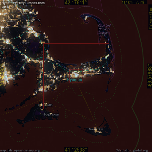
Analysis of Hyannis night lights 2016
Square area 10x10 km:
 3.57%
3.57%90-99
6.66%80-89
5.19%70-79
5.68%60-69
1.95%50-59
5.36%40-49
7.31%30-39
6.49%20-29
15.1%10-19
29.87%0-9
12.82%Square area 50x50 km:
0.24%90-99
0.7%80-89
0.87%70-79
0.72%60-69
0.98%50-59
1.18%40-49
1.6%30-39
1.38%20-29
2.76%10-19
8.22%0-9
81.35%Clear (daylight) street map image can be seen on geolist.org.
Map coordinates:
42° 10' 34" North, 70° 59' 9.3" West
41° 39' 10.4" North, 70° 16' 58.1" West
41° 7' 31.4" North, 69° 34' 46.8" West
Some cities around Hyannis sort by population:
• Barnstable
5.4 km =3.4 mi,  345°
345°
• Yarmouth
7.4 km =4.6 mi,  37°
37°
• Mashpee
16.5 km =10.3 mi,  268°
268°
• South Yarmouth
8.3 km =5.2 mi,  79°
79°
• Centerville
5.4 km =3.4 mi, 265°
• Marstons Mills
11.1 km =6.9 mi, 271°
• West Yarmouth
3.5 km =2.2 mi,  95°
95°
• Yarmouth Port
6.1 km =3.8 mi,  26°
26°
4940190 (p: 14,120)
Sources (retrieved 2019-11-25):
» Earth at Night: Flat Maps 2012, 2016