Homewood night lights from space
Night Light of Homewood (Illinois) from space (United States) Src. Average luminocity for 10x10km area is 92.0969% and for 50x50km: 64.4202%.
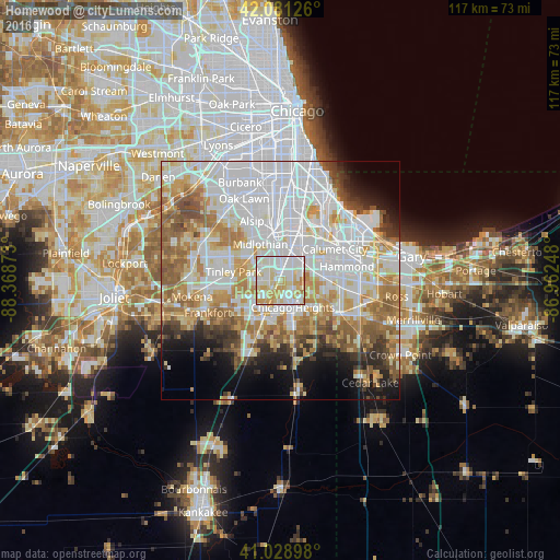
Analysis of Homewood night lights 2016
Square area 10x10 km:
 33.67%
90-99
31.12%80-89
19.05%70-79
14.8%60-69
1.36%50-59
0%40-49
0%30-39
0%20-29
0%10-19
0%0-9
0%Square area 50x50 km:
23.81%90-99
14.3%80-89
7.79%70-79
8.06%60-69
8.51%50-59
6.46%40-49
3.52%30-39
3.45%20-29
4.17%10-19
6.23%0-9
13.71%Clear (daylight) street map image can be seen on geolist.org.
Map coordinates:
42° 4' 52.5" North, 88° 22' 7.4" West
41° 33' 26.1" North, 87° 39' 56.2" West
41° 1' 44.3" North, 86° 57' 44.9" West
Some cities around Homewood sort by population:
• Chicago Heights
6.2 km =3.9 mi,  156°
156°
• Harvey
6.1 km =3.8 mi,  14°
14°
• South Holland
6.9 km =4.3 mi,  45°
45°
• Country Club Hills
4.7 km =2.9 mi,  284°
284°
• Hazel Crest
2.9 km =1.8 mi,  303°
303°
• Markham
4.7 km =2.9 mi,  329°
329°
• Flossmoor
2.3 km =1.4 mi,  224°
224°
• Glenwood
5.5 km =3.4 mi,  107°
107°
4896353 (p: 19,373)
Sources (retrieved 2019-11-25):
» Earth at Night: Flat Maps 2012, 2016