Home Gardens night lights from space
Night Light of Home Gardens (California) from space (United States) Src. Average luminocity for 10x10km area is 78.8724% and for 50x50km: 59.6531%.
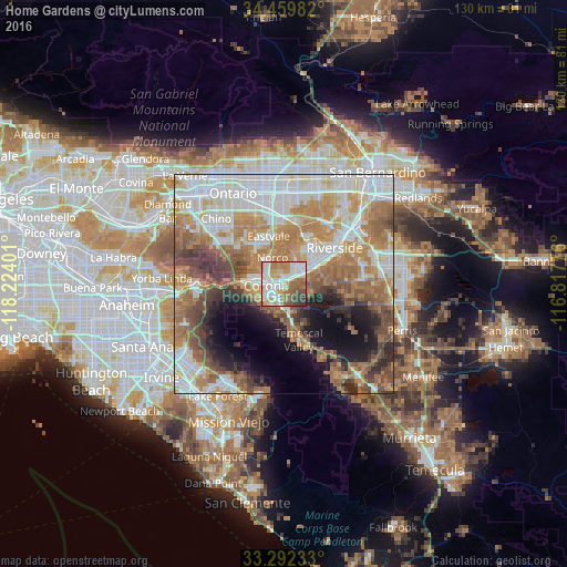
Analysis of Home Gardens night lights 2016
Square area 10x10 km:
 20.63%
90-99
23.43%80-89
6.82%70-79
14.69%60-69
15.56%50-59
9.09%40-49
5.07%30-39
4.72%20-29
0%10-19
0%0-9
0%Square area 50x50 km:
14.38%90-99
13.09%80-89
5.85%70-79
8.75%60-69
14.47%50-59
7.88%40-49
7.2%30-39
4.41%20-29
4.8%10-19
8.39%0-9
10.78%Clear (daylight) street map image can be seen on geolist.org.
Map coordinates:
34° 27' 35.4" North, 118° 13' 26.4" West
33° 52' 41.1" North, 117° 31' 15.2" West
33° 17' 32.4" North, 116° 49' 3.9" West
Some cities around Home Gardens sort by population:
• Riverside
14.2 km =8.8 mi,  53°
53°
• Corona
4.2 km =2.6 mi,  265°
265°
• Eastvale
10.3 km =6.4 mi,  337°
337°
• Norco
6.4 km =4 mi, 336°
• Jurupa Valley
12.7 km =7.9 mi,  1°
1°
• Woodcrest
15.1 km =9.4 mi,  88°
88°
• Pedley
11.6 km =7.2 mi,  21°
21°
• El Cerrito Corona
4.2 km =2.6 mi,  182°
182°
5357731 (p: 11,570)
Sources (retrieved 2019-11-25):
» Earth at Night: Flat Maps 2012, 2016