Hilton night lights from space
Night Light of Hilton (New York) from space (United States) Src. Average luminocity for 10x10km area is 12.4621% and for 50x50km: 18.3831%.
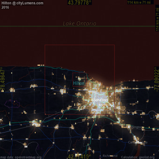
Analysis of Hilton night lights 2016
Square area 10x10 km:
 0.3%
0.3%90-99
0.3%80-89
0.61%70-79
0.61%60-69
2.42%50-59
3.03%40-49
1.67%30-39
5.15%20-29
4.24%10-19
15.61%0-9
66.06%Square area 50x50 km:
4.39%90-99
3.37%80-89
1.78%70-79
2.2%60-69
2.82%50-59
4.19%40-49
2.39%30-39
1.65%20-29
2.49%10-19
4.49%0-9
70.23%Clear (daylight) street map image can be seen on geolist.org.
Map coordinates:
43° 47' 52" North, 78° 29' 47.3" West
43° 17' 17.2" North, 77° 47' 36" West
42° 46' 26.9" North, 77° 5' 24.8" West
Some cities around Hilton sort by population:
• Rochester
20.7 km =12.9 mi,  135°
135°
• Irondequoit
19.2 km =11.9 mi,  115°
115°
• Brighton
25.1 km =15.6 mi,  128°
128°
• Gates-North Gates
15.6 km =9.7 mi,  151°
151°
• Greece
11.9 km =7.4 mi, 137°
• North Gates
14.5 km =9 mi, 149°
• Brockport
14.4 km =8.9 mi,  234°
234°
• Hamlin
10.5 km =6.5 mi,  279°
279°
5120871 (p: 5,921)
Sources (retrieved 2019-11-25):
» Earth at Night: Flat Maps 2012, 2016