Helena-West Helena night lights from space
Night Light of Helena-West Helena (Arkansas) from space (United States) Src. Average luminocity for 10x10km area is 27.0472% and for 50x50km: 3.8846%.
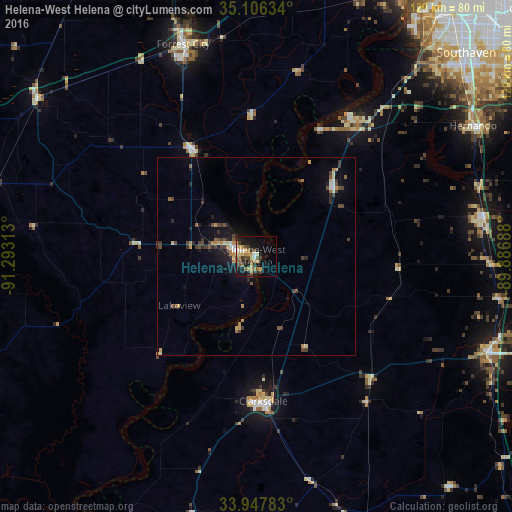
Analysis of Helena-West Helena night lights 2016
Square area 10x10 km:
 1.92%
1.92%90-99
2.27%80-89
5.42%70-79
5.24%60-69
3.67%50-59
5.24%40-49
4.2%30-39
4.72%20-29
4.2%10-19
24.13%0-9
38.99%Square area 50x50 km:
0.21%90-99
0.32%80-89
0.46%70-79
0.65%60-69
0.53%50-59
0.5%40-49
0.88%30-39
1%20-29
0.64%10-19
2.71%0-9
92.11%Clear (daylight) street map image can be seen on geolist.org.
Map coordinates:
35° 6' 22.8" North, 91° 17' 35.3" West
34° 31' 44.8" North, 90° 35' 24" West
33° 56' 52.2" North, 89° 53' 12.8" West
Some cities around Helena-West Helena sort by population:
• Southaven
73.5 km =45.7 mi,  45°
45°
• Horn Lake
69.4 km =43.1 mi, 46°
• Clarksdale
36.6 km =22.7 mi,  177°
177°
• Hernando
63.6 km =39.5 mi,  58°
58°
• Forrest City
56.3 km =35 mi,  341°
341°
• Senatobia
57.7 km =35.9 mi,  80°
80°
• West Helena
5.3 km =3.3 mi,  296°
296°
• Batesville
64 km =39.8 mi,  112°
112°
6331911 (p: 11,109)
Sources (retrieved 2019-11-25):
» Earth at Night: Flat Maps 2012, 2016