Hackettstown night lights from space
Night Light of Hackettstown (New Jersey) from space (United States) Src. Average luminocity for 10x10km area is 26.017% and for 50x50km: 17.0127%.
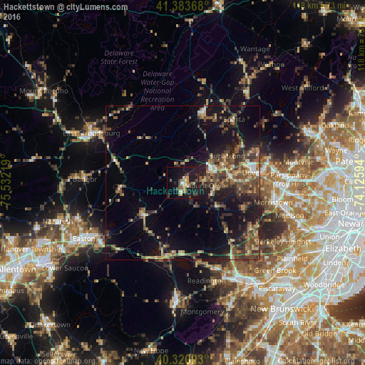
Analysis of Hackettstown night lights 2016
Square area 10x10 km:
 1.36%
1.36%90-99
2.72%80-89
3.06%70-79
4.08%60-69
4.08%50-59
4.59%40-49
3.57%30-39
4.59%20-29
5.27%10-19
39.46%0-9
27.21%Square area 50x50 km:
0.74%90-99
1.12%80-89
2.01%70-79
2.42%60-69
2.5%50-59
3.88%40-49
4.5%30-39
4.01%20-29
4.88%10-19
13.33%0-9
60.61%Clear (daylight) street map image can be seen on geolist.org.
Map coordinates:
41° 23' 1.2" North, 75° 31' 55.9" West
40° 51' 14.4" North, 74° 49' 44.6" West
40° 19' 12.1" North, 74° 7' 33.4" West
Some cities around Hackettstown sort by population:
• Randolph
20.8 km =12.9 mi,  91°
91°
• Hopatcong Hills
16.7 km =10.4 mi,  53°
53°
• Hopatcong
16.7 km =10.4 mi,  58°
58°
• Succasunna
15.9 km =9.9 mi,  84°
84°
• Budd Lake
8.2 km =5.1 mi, 76°
• Washington
16.5 km =10.3 mi,  229°
229°
• Landing
14.9 km =9.3 mi,  67°
67°
• Mount Arlington
18.2 km =11.3 mi, 63°
5098745 (p: 9,579)
Sources (retrieved 2019-11-25):
» Earth at Night: Flat Maps 2012, 2016