Landing night lights from space
Night Light of Landing (New Jersey) from space (United States) Src. Average luminocity for 10x10km area is 53.4983% and for 50x50km: 24.4907%.
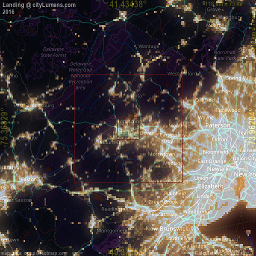
Analysis of Landing night lights 2016
Square area 10x10 km:
 3.06%
3.06%90-99
4.76%80-89
11.05%70-79
8.84%60-69
7.65%50-59
13.78%40-49
22.96%30-39
10.2%20-29
12.93%10-19
4.76%0-9
0%Square area 50x50 km:
2.31%90-99
2.6%80-89
2.77%70-79
3.5%60-69
5.33%50-59
4.98%40-49
4.91%30-39
4.89%20-29
6.72%10-19
13.06%0-9
48.92%Clear (daylight) street map image can be seen on geolist.org.
Map coordinates:
41° 26' 3.8" North, 75° 22' 5.8" West
40° 54' 18.4" North, 74° 39' 54.6" West
40° 22' 17.6" North, 73° 57' 43.3" West
Some cities around Landing sort by population:
• Randolph
9.5 km =5.9 mi,  131°
131°
• Dover
9 km =5.6 mi,  105°
105°
• Hopatcong Hills
4.3 km =2.7 mi,  353°
353°
• Hopatcong
3.1 km =1.9 mi,  9°
9°
• Succasunna
4.6 km =2.9 mi,  152°
152°
• Budd Lake
6.9 km =4.3 mi,  236°
236°
• Wharton
7.1 km =4.4 mi,  100°
100°
• Mount Arlington
3.4 km =2.1 mi,  47°
47°
5100308 (p: 6,436)
Sources (retrieved 2019-11-25):
» Earth at Night: Flat Maps 2012, 2016