Gulf Hills night lights from space
Night Light of Gulf Hills (Mississippi) from space (United States) Src. Average luminocity for 10x10km area is 69.8718% and for 50x50km: 20.851%.
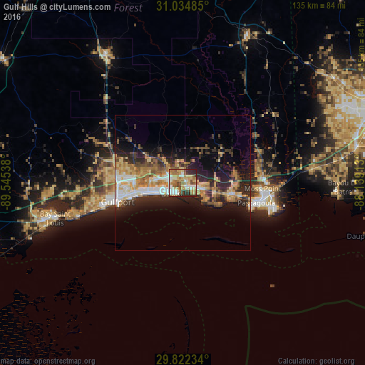
Analysis of Gulf Hills night lights 2016
Square area 10x10 km:
 13%
13%90-99
14.65%80-89
13.37%70-79
11.36%60-69
17.03%50-59
7.69%40-49
8.24%30-39
3.66%20-29
10.62%10-19
0.37%0-9
0%Square area 50x50 km:
2.78%90-99
3.05%80-89
3.31%70-79
3.22%60-69
3.89%50-59
2.31%40-49
2.74%30-39
2.98%20-29
7.12%10-19
10.08%0-9
58.52%Clear (daylight) street map image can be seen on geolist.org.
Map coordinates:
31° 2' 5.5" North, 89° 32' 43.4" West
30° 25' 49.7" North, 88° 50' 32.1" West
29° 49' 20.4" North, 88° 8' 20.9" West
Some cities around Gulf Hills sort by population:
• West Gulfport
24.3 km =15.1 mi,  263°
263°
• Biloxi
5.6 km =3.5 mi,  227°
227°
• Gautier
22.7 km =14.1 mi,  102°
102°
• Ocean Springs
2.5 km =1.6 mi,  146°
146°
• D'Iberville
4.7 km =2.9 mi, 264°
• Saint Martin
2.6 km =1.6 mi,  288°
288°
• Latimer
11.8 km =7.3 mi,  348°
348°
• Vancleave
19.2 km =11.9 mi,  50°
50°
4428654 (p: 7,144)
Sources (retrieved 2019-11-25):
» Earth at Night: Flat Maps 2012, 2016