Latimer night lights from space
Night Light of Latimer (Mississippi) from space (United States) Src. Average luminocity for 10x10km area is 16.1978% and for 50x50km: 21.6774%.
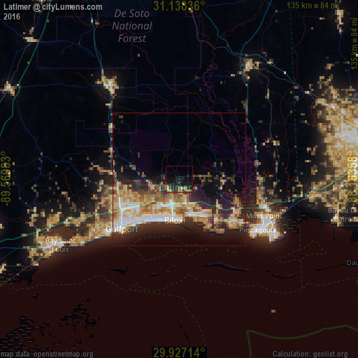
Analysis of Latimer night lights 2016
Square area 10x10 km:
 0%
0%90-99
0%80-89
2.93%70-79
2.56%60-69
3.3%50-59
2.38%40-49
0.73%30-39
2.93%20-29
9.34%10-19
22.34%0-9
53.48%Square area 50x50 km:
2.85%90-99
3.2%80-89
3.76%70-79
3.33%60-69
4.11%50-59
2.46%40-49
2.86%30-39
3.06%20-29
6.77%10-19
9.6%0-9
57.98%Clear (daylight) street map image can be seen on geolist.org.
Map coordinates:
31° 8' 18.1" North, 89° 34' 11.4" West
30° 32' 4.7" North, 88° 52' 0.1" West
29° 55' 37.7" North, 88° 9' 48.9" West
Some cities around Latimer sort by population:
• West Gulfport
26.2 km =16.3 mi,  236°
236°
• Biloxi
15.5 km =9.6 mi,  186°
186°
• Ocean Springs
14.2 km =8.8 mi,  164°
164°
• D'Iberville
12.3 km =7.6 mi, 190°
• Saint Martin
10.7 km =6.6 mi,  180°
180°
• Gulf Hills
11.8 km =7.3 mi,  168°
168°
• Vancleave
17.2 km =10.7 mi,  87°
87°
• Gulf Park Estates
18.8 km =11.7 mi,  147°
147°
4433016 (p: 6,079)
Sources (retrieved 2019-11-25):
» Earth at Night: Flat Maps 2012, 2016