Saint Martin night lights from space
Night Light of Saint Martin (Mississippi) from space (United States) Src. Average luminocity for 10x10km area is 75.641% and for 50x50km: 22.0271%.
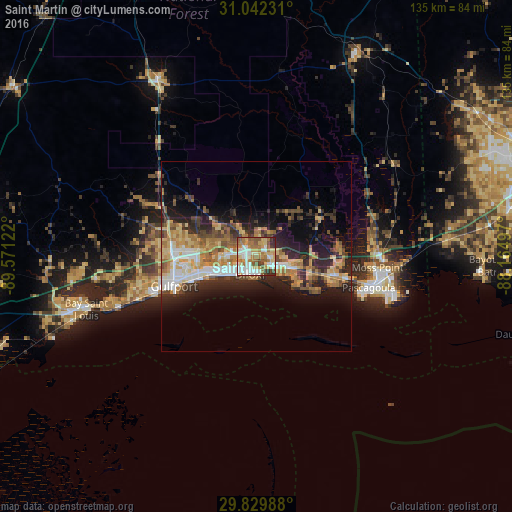
Analysis of Saint Martin night lights 2016
Square area 10x10 km:
 16.12%
90-99
17.95%80-89
13.74%70-79
11.72%60-69
18.13%50-59
9.34%40-49
6.41%30-39
3.3%20-29
3.3%10-19
0%0-9
0%Square area 50x50 km:
2.91%90-99
3.26%80-89
3.83%70-79
3.4%60-69
4.18%50-59
2.51%40-49
2.9%30-39
3.04%20-29
6.89%10-19
9.73%0-9
57.34%Clear (daylight) street map image can be seen on geolist.org.
Map coordinates:
31° 2' 32.3" North, 89° 34' 16.4" West
30° 26' 16.7" North, 88° 52' 5.1" West
29° 49' 47.6" North, 88° 9' 53.9" West
Some cities around Saint Martin sort by population:
• West Gulfport
22 km =13.7 mi,  260°
260°
• Biloxi
4.9 km =3 mi,  199°
199°
• Ocean Springs
4.9 km =3 mi,  127°
127°
• D'Iberville
2.5 km =1.6 mi,  239°
239°
• Gulf Hills
2.6 km =1.6 mi,  108°
108°
• Latimer
10.7 km =6.6 mi,  0°
0°
• Vancleave
20.7 km =12.9 mi,  56°
56°
• Gulf Park Estates
11.5 km =7.1 mi,  116°
116°
4447069 (p: 7,730)
Sources (retrieved 2019-11-25):
» Earth at Night: Flat Maps 2012, 2016