D'Iberville night lights from space
Night Light of D'Iberville (Mississippi) from space (United States) Src. Average luminocity for 10x10km area is 78.0183% and for 50x50km: 23.184%.
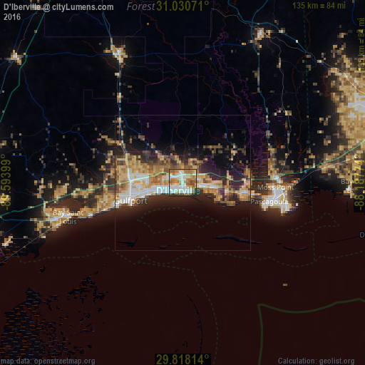
Analysis of D'Iberville night lights 2016
Square area 10x10 km:
 20.88%
90-99
21.79%80-89
6.41%70-79
12.64%60-69
19.96%50-59
6.96%40-49
6.23%30-39
3.66%20-29
1.47%10-19
0%0-9
0%Square area 50x50 km:
3.03%90-99
3.32%80-89
4.23%70-79
3.63%60-69
4.41%50-59
2.78%40-49
3.2%30-39
3.27%20-29
6.74%10-19
9.81%0-9
55.57%Clear (daylight) street map image can be seen on geolist.org.
Map coordinates:
31° 1' 50.6" North, 89° 35' 38.4" West
30° 25' 34.7" North, 88° 53' 27.1" West
29° 49' 5.3" North, 88° 11' 15.9" West
Some cities around D'Iberville sort by population:
• Gulfport
20.4 km =12.7 mi,  251°
251°
• West Gulfport
19.7 km =12.2 mi,  262°
262°
• Biloxi
3.4 km =2.1 mi,  171°
171°
• Ocean Springs
6.3 km =3.9 mi,  105°
105°
• Saint Martin
2.5 km =1.6 mi,  59°
59°
• Gulf Hills
4.7 km =2.9 mi,  84°
84°
• Latimer
12.3 km =7.6 mi,  10°
10°
• Gulf Park Estates
13 km =8.1 mi, 107°
4423395 (p: 11,400)
Sources (retrieved 2019-11-25):
» Earth at Night: Flat Maps 2012, 2016