Gautier night lights from space
Night Light of Gautier (Mississippi) from space (United States) Src. Average luminocity for 10x10km area is 48.2802% and for 50x50km: 15.9103%.
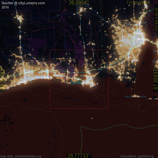
Analysis of Gautier night lights 2016
Square area 10x10 km:
 4.58%
4.58%90-99
5.31%80-89
8.97%70-79
12.82%60-69
6.96%50-59
3.48%40-49
5.49%30-39
9.34%20-29
31.14%10-19
11.9%0-9
0%Square area 50x50 km:
1.37%90-99
1.54%80-89
2.43%70-79
2.44%60-69
2.76%50-59
1.91%40-49
2.8%30-39
3.09%20-29
6.47%10-19
10.56%0-9
64.63%Clear (daylight) street map image can be seen on geolist.org.
Map coordinates:
30° 59' 25.4" North, 89° 18' 53.4" West
30° 23' 8.7" North, 88° 36' 42.1" West
29° 46' 38.4" North, 87° 54' 30.9" West
Some cities around Gautier sort by population:
• Biloxi
26.3 km =16.3 mi,  272°
272°
• Pascagoula
5.8 km =3.6 mi,  112°
112°
• Ocean Springs
20.9 km =13 mi,  277°
277°
• Moss Point
7.9 km =4.9 mi,  68°
68°
• Saint Martin
25.3 km =15.7 mi, 283°
• Gulf Hills
22.7 km =14.1 mi, 282°
• Vancleave
18.7 km =11.6 mi,  337°
337°
• Gulf Park Estates
14.4 km =8.9 mi, 272°
4427569 (p: 18,570)
Sources (retrieved 2019-11-25):
» Earth at Night: Flat Maps 2012, 2016