Chalco night lights from space
Night Light of Chalco (Nebraska) from space (United States) Src. Average luminocity for 10x10km area is 85.8166% and for 50x50km: 32.7971%.
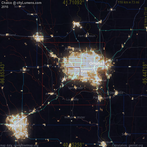
Analysis of Chalco night lights 2016
Square area 10x10 km:
 30.36%
90-99
30.03%80-89
8.12%70-79
10.55%60-69
9.74%50-59
5.52%40-49
3.41%30-39
0.65%20-29
1.62%10-19
0%0-9
0%Square area 50x50 km:
10.22%90-99
8.37%80-89
3.51%70-79
2.66%60-69
3.65%50-59
2.78%40-49
2.61%30-39
2.96%20-29
5.49%10-19
8.57%0-9
49.2%Clear (daylight) street map image can be seen on geolist.org.
Map coordinates:
41° 42' 39.3" North, 96° 51' 12.3" West
41° 11' 2" North, 96° 9' 1.1" West
40° 39' 9.3" North, 95° 26' 49.8" West
Some cities around Chalco sort by population:
• Omaha
19.3 km =12 mi,  65°
65°
• Council Bluffs
25.7 km =16 mi, 70°
• Bellevue
22.3 km =13.9 mi,  103°
103°
• Papillion
9.6 km =6 mi,  109°
109°
• La Vista
10 km =6.2 mi,  90°
90°
• Elkhorn
13.4 km =8.3 mi,  328°
328°
• Ralston
9.3 km =5.8 mi,  75°
75°
• Gretna
8.9 km =5.5 mi,  237°
237°
5065495 (p: 10,994)
Sources (retrieved 2019-11-25):
» Earth at Night: Flat Maps 2012, 2016