Grenada night lights from space
Night Light of Grenada (Mississippi) from space (United States) Src. Average luminocity for 10x10km area is 45.4048% and for 50x50km: 4.0266%.
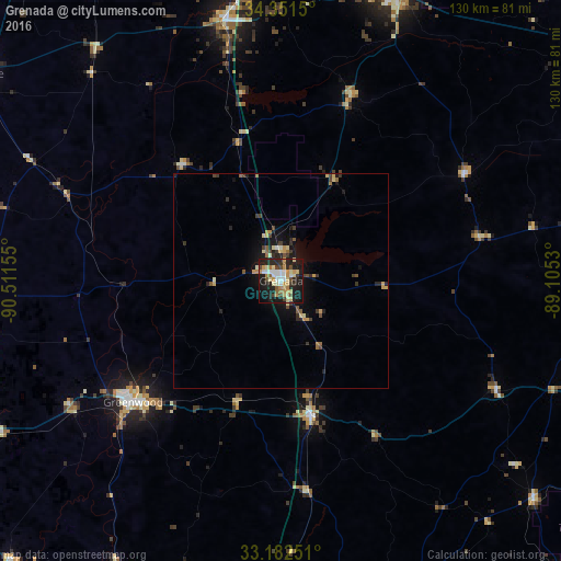
Analysis of Grenada night lights 2016
Square area 10x10 km:
 6.04%
6.04%90-99
8.24%80-89
8.79%70-79
8.24%60-69
4.95%50-59
3.48%40-49
5.31%30-39
4.03%20-29
19.96%10-19
28.39%0-9
2.56%Square area 50x50 km:
0.25%90-99
0.43%80-89
0.76%70-79
0.61%60-69
0.43%50-59
0.46%40-49
0.59%30-39
0.72%20-29
1.39%10-19
3.28%0-9
91.08%Clear (daylight) street map image can be seen on geolist.org.
Map coordinates:
34° 21' 5.4" North, 90° 30' 41.6" West
33° 46' 8.4" North, 89° 48' 30.3" West
33° 10' 57" North, 89° 6' 19.1" West
Some cities around Grenada sort by population:
• Oxford
71.6 km =44.5 mi,  21°
21°
• Clarksdale
85.1 km =52.9 mi,  304°
304°
• Greenwood
44.4 km =27.6 mi,  230°
230°
• Cleveland
84.8 km =52.7 mi,  268°
268°
• Indianola
86 km =53.4 mi,  245°
245°
• Batesville
61.6 km =38.3 mi,  348°
348°
• Kosciusko
81.6 km =50.7 mi,  165°
165°
• Pontotoc
91.7 km =57 mi,  54°
54°
4428539 (p: 12,900)
Sources (retrieved 2019-11-25):
» Earth at Night: Flat Maps 2012, 2016