Erwin night lights from space
Night Light of Erwin (Tennessee) from space (United States) Src. Average luminocity for 10x10km area is 25.4066% and for 50x50km: 10.946%.
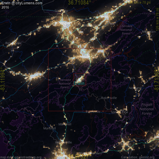
Analysis of Erwin night lights 2016
Square area 10x10 km:
 3.11%
3.11%90-99
3.48%80-89
3.11%70-79
4.03%60-69
3.48%50-59
1.83%40-49
4.03%30-39
3.66%20-29
3.85%10-19
27.29%0-9
42.12%Square area 50x50 km:
1.22%90-99
1.34%80-89
1.35%70-79
1.52%60-69
2.04%50-59
1.72%40-49
1.83%30-39
2.64%20-29
3.01%10-19
5.65%0-9
77.69%Clear (daylight) street map image can be seen on geolist.org.
Map coordinates:
36° 42' 39" North, 83° 7' 11.8" West
36° 8' 42.4" North, 82° 25' 0.5" West
35° 34' 31" North, 81° 42' 49.3" West
Some cities around Erwin sort by population:
• Johnson City
19.6 km =12.2 mi,  16°
16°
• Kingsport
46.7 km =29 mi,  343°
343°
• Greeneville
37.2 km =23.1 mi,  273°
273°
• Elizabethton
29.2 km =18.1 mi,  39°
39°
• Bloomingdale
49.3 km =30.6 mi,  352°
352°
• Colonial Heights
38.6 km =24 mi, 348°
• Mount Carmel
49.6 km =30.8 mi,  333°
333°
• Jonesborough
17.3 km =10.7 mi, 342°
4621130 (p: 5,979)
Sources (retrieved 2019-11-25):
» Earth at Night: Flat Maps 2012, 2016