Grand Haven night lights from space
Night Light of Grand Haven (Michigan) from space (United States) Src. Average luminocity for 10x10km area is 33.7397% and for 50x50km: 9.9502%.
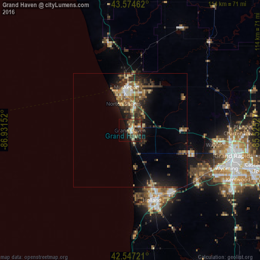
Analysis of Grand Haven night lights 2016
Square area 10x10 km:
 2.06%
2.06%90-99
5.08%80-89
3.97%70-79
5.56%60-69
5.87%50-59
4.76%40-49
7.78%30-39
6.98%20-29
13.17%10-19
20.48%0-9
24.29%Square area 50x50 km:
0.59%90-99
1.16%80-89
1.59%70-79
1.12%60-69
1.5%50-59
1.88%40-49
2.03%30-39
2.05%20-29
3.77%10-19
5.94%0-9
78.38%Clear (daylight) street map image can be seen on geolist.org.
Map coordinates:
43° 34' 28.6" North, 86° 55' 53.5" West
43° 3' 47.1" North, 86° 13' 42.2" West
42° 32' 50" North, 85° 31' 31" West
Some cities around Grand Haven sort by population:
• Muskegon
19.1 km =11.9 mi,  355°
355°
• Holland
32.1 km =19.9 mi,  162°
162°
• Walker
38 km =23.6 mi,  100°
100°
• Norton Shores
12.1 km =7.5 mi,  346°
346°
• Allendale
24.5 km =15.2 mi,  114°
114°
• Muskegon Heights
15.4 km =9.6 mi, 356°
• Hudsonville
36.5 km =22.7 mi,  125°
125°
• Zeeland
32.7 km =20.3 mi,  148°
148°
4994325 (p: 11,062)
Sources (retrieved 2019-11-25):
» Earth at Night: Flat Maps 2012, 2016