Allendale night lights from space
Night Light of Allendale (Michigan) from space (United States) Src. Average luminocity for 10x10km area is 13.4794% and for 50x50km: 22.9668%.
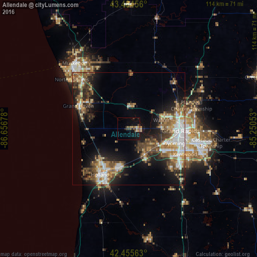
Analysis of Allendale night lights 2016
Square area 10x10 km:
 0.95%
0.95%90-99
1.43%80-89
1.75%70-79
1.27%60-69
1.27%50-59
3.17%40-49
1.75%30-39
3.17%20-29
1.75%10-19
14.44%0-9
69.05%Square area 50x50 km:
3.52%90-99
3.69%80-89
2.6%70-79
2.69%60-69
3.61%50-59
3.81%40-49
4.81%30-39
3.62%20-29
5.63%10-19
10.63%0-9
55.37%Clear (daylight) street map image can be seen on geolist.org.
Map coordinates:
43° 29' 4.4" North, 86° 39' 24.4" West
42° 58' 20.1" North, 85° 57' 13.1" West
42° 27' 20.3" North, 85° 15' 1.9" West
Some cities around Allendale sort by population:
• Grand Rapids
23.3 km =14.5 mi,  92°
92°
• Wyoming
21.2 km =13.2 mi,  107°
107°
• Holland
24.1 km =15 mi,  211°
211°
• Walker
15.4 km =9.6 mi,  77°
77°
• Jenison
15 km =9.3 mi,  118°
118°
• Grandville
17 km =10.6 mi, 114°
• Hudsonville
13.4 km =8.3 mi,  147°
147°
• Zeeland
18.5 km =11.5 mi,  196°
196°
4984029 (p: 17,579)
Sources (retrieved 2019-11-25):
» Earth at Night: Flat Maps 2012, 2016