Gilmer night lights from space
Night Light of Gilmer (Texas) from space (United States) Src. Average luminocity for 10x10km area is 24.049% and for 50x50km: 11.9516%.
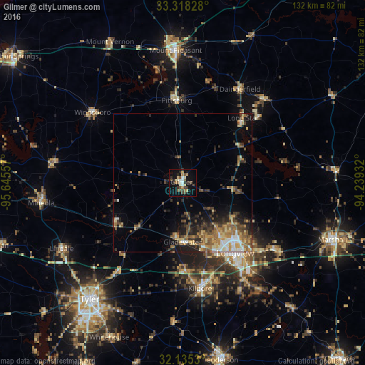
Analysis of Gilmer night lights 2016
Square area 10x10 km:
 1.75%
1.75%90-99
3.5%80-89
3.85%70-79
1.4%60-69
2.8%50-59
4.2%40-49
5.42%30-39
4.9%20-29
2.97%10-19
25.52%0-9
43.71%Square area 50x50 km:
0.95%90-99
1.43%80-89
1.85%70-79
1.79%60-69
1.83%50-59
2.5%40-49
1.76%30-39
2.76%20-29
2.46%10-19
5.49%0-9
77.16%Clear (daylight) street map image can be seen on geolist.org.
Map coordinates:
33° 19' 5.8" North, 95° 38' 44.1" West
32° 43' 43.5" North, 94° 56' 32.8" West
32° 8' 7.1" North, 94° 14' 21.6" West
Some cities around Gilmer sort by population:
• Tyler
53.8 km =33.4 mi,  218°
218°
• Longview
31.6 km =19.6 mi,  143°
143°
• Marshall
57.6 km =35.8 mi,  110°
110°
• Mount Pleasant
47.7 km =29.6 mi,  357°
357°
• Kilgore
38.6 km =24 mi,  170°
170°
• Gladewater
21.4 km =13.3 mi,  180°
180°
• White Oak
23.6 km =14.7 mi,  161°
161°
• Lindale
49.7 km =30.9 mi,  241°
241°
4693569 (p: 5,187)
Sources (retrieved 2019-11-25):
» Earth at Night: Flat Maps 2012, 2016