Gantt night lights from space
Night Light of Gantt (South Carolina) from space (United States) Src. Average luminocity for 10x10km area is 85.9524% and for 50x50km: 46.1602%.
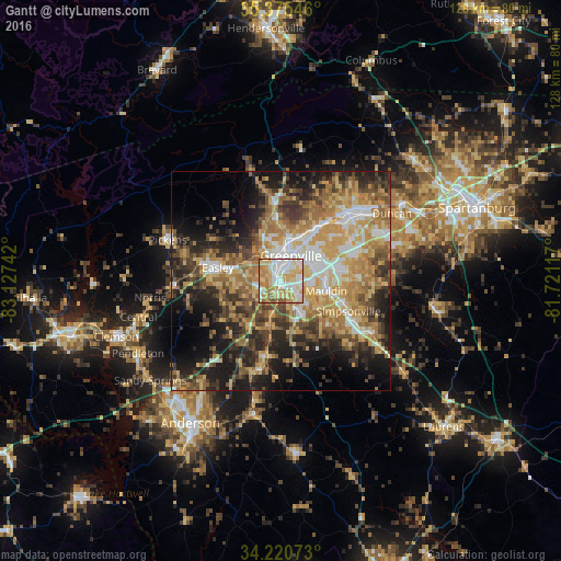
Analysis of Gantt night lights 2016
Square area 10x10 km:
 23.26%
90-99
21.98%80-89
23.63%70-79
16.3%60-69
11.17%50-59
2.93%40-49
0.73%30-39
0%20-29
0%10-19
0%0-9
0%Square area 50x50 km:
6.01%90-99
6.22%80-89
8.97%70-79
9.2%60-69
9.01%50-59
6.61%40-49
6.54%30-39
7.96%20-29
9.4%10-19
12.86%0-9
17.21%Clear (daylight) street map image can be seen on geolist.org.
Map coordinates:
35° 22' 31.7" North, 83° 7' 38.7" West
34° 48' 0.4" North, 82° 25' 27.4" West
34° 13' 14.6" North, 81° 43' 16.2" West
Some cities around Gantt sort by population:
• Greenville
6.5 km =4 mi,  25°
25°
• Mauldin
10.7 km =6.6 mi,  102°
102°
• Berea
9.9 km =6.2 mi,  343°
343°
• Parker
6.2 km =3.9 mi,  334°
334°
• Sans Souci
8.6 km =5.3 mi,  0°
0°
• Powdersville
6.3 km =3.9 mi,  261°
261°
• Welcome
3.2 km =2 mi, 335°
• Piedmont
11.5 km =7.1 mi,  198°
198°
4579484 (p: 14,229)
Sources (retrieved 2019-11-25):
» Earth at Night: Flat Maps 2012, 2016