Berea night lights from space
Night Light of Berea (South Carolina) from space (United States) Src. Average luminocity for 10x10km area is 69.9121% and for 50x50km: 41.471%.
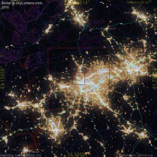
Analysis of Berea night lights 2016
Square area 10x10 km:
 14.29%
90-99
15.57%80-89
9.89%70-79
13%60-69
16.67%50-59
8.24%40-49
8.06%30-39
4.58%20-29
6.96%10-19
2.75%0-9
0%Square area 50x50 km:
5.83%90-99
6.04%80-89
8.06%70-79
8.59%60-69
8.38%50-59
5.3%40-49
5.61%30-39
6.65%20-29
7.06%10-19
8.77%0-9
29.72%Clear (daylight) street map image can be seen on geolist.org.
Map coordinates:
35° 27' 36.5" North, 83° 9' 32.7" West
34° 53' 7.4" North, 82° 27' 21.5" West
34° 18' 23.8" North, 81° 45' 10.2" West
Some cities around Berea sort by population:
• Greenville
6.7 km =4.2 mi,  122°
122°
• Easley
14.6 km =9.1 mi,  245°
245°
• Wade Hampton
11.4 km =7.1 mi,  79°
79°
• Gantt
9.9 km =6.2 mi,  163°
163°
• Parker
3.9 km =2.4 mi,  176°
176°
• Sans Souci
3 km =1.9 mi,  105°
105°
• Powdersville
10.9 km =6.8 mi,  197°
197°
• Welcome
6.7 km =4.2 mi,  166°
166°
4570664 (p: 14,295)
Sources (retrieved 2019-11-25):
» Earth at Night: Flat Maps 2012, 2016