Gainesville night lights from space
Night Light of Gainesville (Virginia) from space (United States) Src. Average luminocity for 10x10km area is 66.8571% and for 50x50km: 31.5773%.
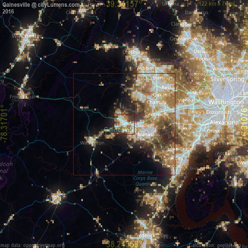
Analysis of Gainesville night lights 2016
Square area 10x10 km:
 11.22%
90-99
17.35%80-89
9.52%70-79
11.9%60-69
11.73%50-59
9.52%40-49
6.12%30-39
11.22%20-29
11.39%10-19
0%0-9
0%Square area 50x50 km:
5.15%90-99
6.25%80-89
4.02%70-79
5.36%60-69
6.81%50-59
4.42%40-49
3.64%30-39
4.68%20-29
5.76%10-19
7.1%0-9
46.82%Clear (daylight) street map image can be seen on geolist.org.
Map coordinates:
39° 20' 29.7" North, 78° 19' 1.2" West
38° 47' 44.4" North, 77° 36' 50" West
38° 14' 44" North, 76° 54' 38.7" West
Some cities around Gainesville sort by population:
• Manassas
13 km =8.1 mi,  112°
112°
• Linton Hall
5.2 km =3.2 mi,  139°
139°
• Sudley
10.1 km =6.3 mi,  91°
91°
• Manassas Park
12.6 km =7.8 mi,  95°
95°
• Bull Run
8.2 km =5.1 mi, 99°
• New Baltimore
10.4 km =6.5 mi,  252°
252°
• West Gate
10.2 km =6.3 mi, 98°
• Yorkshire
14.4 km =8.9 mi, 91°
4760363 (p: 11,481)
Sources (retrieved 2019-11-25):
» Earth at Night: Flat Maps 2012, 2016