Francisville night lights from space
Night Light of Francisville (Kentucky) from space (United States) Src. Average luminocity for 10x10km area is 49.6071% and for 50x50km: 40.7994%.
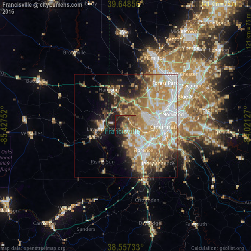
Analysis of Francisville night lights 2016
Square area 10x10 km:
 5.36%
5.36%90-99
4.22%80-89
3.08%70-79
10.06%60-69
12.01%50-59
20.13%40-49
7.47%30-39
6.82%20-29
14.12%10-19
16.4%0-9
0.32%Square area 50x50 km:
8.83%90-99
8.72%80-89
5.49%70-79
7.45%60-69
7.08%50-59
5.19%40-49
3.43%30-39
3.33%20-29
5.32%10-19
9.42%0-9
35.74%Clear (daylight) street map image can be seen on geolist.org.
Map coordinates:
39° 38' 54.8" North, 85° 25' 39.1" West
39° 6' 18.2" North, 84° 43' 27.8" West
38° 33' 26.4" North, 84° 1' 16.6" West
Some cities around Francisville sort by population:
• Burlington
8.6 km =5.3 mi,  179°
179°
• Bridgetown
9.2 km =5.7 mi,  54°
54°
• Mack
8.7 km =5.4 mi, 47°
• Dent
11 km =6.8 mi,  35°
35°
• Cheviot
11.2 km =7 mi,  58°
58°
• Covedale
10.3 km =6.4 mi,  80°
80°
• Hebron
4.8 km =3 mi,  155°
155°
• Delhi Hills
9.7 km =6 mi,  98°
98°
4292182 (p: 7,944)
Sources (retrieved 2019-11-25):
» Earth at Night: Flat Maps 2012, 2016