Cheviot night lights from space
Night Light of Cheviot (Ohio) from space (United States) Src. Average luminocity for 10x10km area is 81.7549% and for 50x50km: 54.6118%.
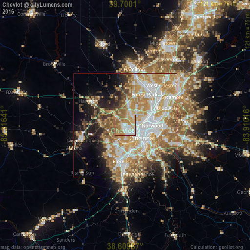
Analysis of Cheviot night lights 2016
Square area 10x10 km:
 17.37%
90-99
21.43%80-89
14.45%70-79
18.18%60-69
23.05%50-59
5.52%40-49
0%30-39
0%20-29
0%10-19
0%0-9
0%Square area 50x50 km:
11.78%90-99
12.28%80-89
7.53%70-79
10.77%60-69
10.38%50-59
6.83%40-49
3.74%30-39
3.72%20-29
5.65%10-19
9.68%0-9
17.65%Clear (daylight) street map image can be seen on geolist.org.
Map coordinates:
39° 42' 0.4" North, 85° 18' 59.1" West
39° 9' 25.2" North, 84° 36' 47.8" West
38° 36' 34.8" North, 83° 54' 36.6" West
Some cities around Cheviot sort by population:
• White Oak
6.4 km =4 mi,  10°
10°
• Bridgetown
2.1 km =1.3 mi,  258°
258°
• Monfort Heights
3.8 km =2.4 mi,  24°
24°
• Mack
3.1 km =1.9 mi,  272°
272°
• Dent
4.6 km =2.9 mi,  314°
314°
• Groesbeck
7.7 km =4.8 mi, 17°
• Covedale
4 km =2.5 mi,  171°
171°
• Delhi Hills
7.1 km =4.4 mi,  179°
179°
4508465 (p: 8,295)
Sources (retrieved 2019-11-25):
» Earth at Night: Flat Maps 2012, 2016