Dent night lights from space
Night Light of Dent (Ohio) from space (United States) Src. Average luminocity for 10x10km area is 69.3523% and for 50x50km: 51.4612%.
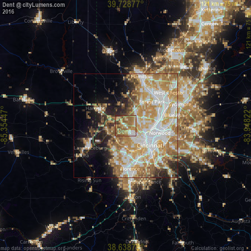
Analysis of Dent night lights 2016
Square area 10x10 km:
 7.63%
7.63%90-99
8.77%80-89
12.01%70-79
14.29%60-69
27.27%50-59
19.32%40-49
7.31%30-39
2.76%20-29
0.65%10-19
0%0-9
0%Square area 50x50 km:
11.44%90-99
11.74%80-89
7.29%70-79
9.93%60-69
9.68%50-59
5.76%40-49
3.51%30-39
3.46%20-29
5.26%10-19
8.37%0-9
23.57%Clear (daylight) street map image can be seen on geolist.org.
Map coordinates:
39° 43' 43.6" North, 85° 21' 16.1" West
39° 11' 9.2" North, 84° 39' 4.8" West
38° 38' 19.6" North, 83° 56' 53.6" West
Some cities around Dent sort by population:
• White Oak
5.4 km =3.4 mi,  55°
55°
• Bridgetown
3.8 km =2.4 mi,  161°
161°
• Monfort Heights
4.8 km =3 mi,  86°
86°
• Mack
3.1 km =1.9 mi,  177°
177°
• Northbrook
8.9 km =5.5 mi,  40°
40°
• Cheviot
4.6 km =2.9 mi,  134°
134°
• Groesbeck
6.9 km =4.3 mi,  53°
53°
• Covedale
8.2 km =5.1 mi,  151°
151°
4510062 (p: 10,497)
Sources (retrieved 2019-11-25):
» Earth at Night: Flat Maps 2012, 2016