Groveton night lights from space
Night Light of Groveton (Virginia) from space (United States) Src. Average luminocity for 10x10km area is 81.2772% and for 50x50km: 68.0702%.
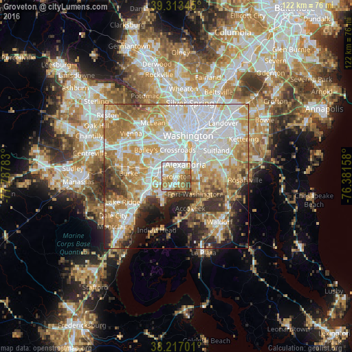
Analysis of Groveton night lights 2016
Square area 10x10 km:
 23.81%
90-99
19.9%80-89
13.95%70-79
12.41%60-69
14.8%50-59
8.5%40-49
6.29%30-39
0.34%20-29
0%10-19
0%0-9
0%Square area 50x50 km:
21.33%90-99
14.43%80-89
9.16%70-79
11.89%60-69
10.22%50-59
6.34%40-49
3.97%30-39
5.12%20-29
6.02%10-19
6.09%0-9
5.44%Clear (daylight) street map image can be seen on geolist.org.
Map coordinates:
39° 18' 48.4" North, 77° 47' 16.2" West
38° 46' 2.4" North, 77° 5' 4.9" West
38° 13' 1.2" North, 76° 22' 53.7" West
Some cities around Groveton sort by population:
• Alexandria
5.3 km =3.3 mi,  38°
38°
• Rose Hill
3.4 km =2.1 mi,  314°
314°
• Franconia
5.6 km =3.5 mi,  287°
287°
• Fort Hunt
4.5 km =2.8 mi,  148°
148°
• Hybla Valley
2.2 km =1.4 mi,  176°
176°
• Mount Vernon
6.1 km =3.8 mi,  193°
193°
• Huntington
3 km =1.9 mi,  23°
23°
• Belle Haven
2.7 km =1.7 mi, 43°
4762493 (p: 14,598)
Sources (retrieved 2019-11-25):
» Earth at Night: Flat Maps 2012, 2016