Finley night lights from space
Night Light of Finley (Washington) from space (United States) Src. Average luminocity for 10x10km area is 13.0426% and for 50x50km: 10.7959%.
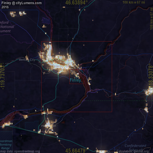
Analysis of Finley night lights 2016
Square area 10x10 km:
 0.71%
0.71%90-99
0.43%80-89
0%70-79
0.57%60-69
1.7%50-59
1.85%40-49
5.26%30-39
6.82%20-29
4.55%10-19
14.63%0-9
63.49%Square area 50x50 km:
1.8%90-99
1.92%80-89
1.26%70-79
1.19%60-69
1.28%50-59
2%40-49
1.87%30-39
1.7%20-29
2.68%10-19
5.35%0-9
78.95%Clear (daylight) street map image can be seen on geolist.org.
Map coordinates:
46° 38' 20.2" North, 119° 44' 13.3" West
46° 9' 14.5" North, 119° 2' 2" West
45° 39' 53.2" North, 118° 19' 50.8" West
Some cities around Finley sort by population:
• Kennewick
10.2 km =6.3 mi,  308°
308°
• Pasco
10.8 km =6.7 mi,  331°
331°
• Richland
24.2 km =15 mi, 307°
• Walla Walla
54.2 km =33.7 mi,  100°
100°
• Hermiston
40.1 km =24.9 mi,  209°
209°
• West Richland
30.2 km =18.8 mi,  303°
303°
• College Place
51.1 km =31.8 mi, 103°
• Umatilla
35.5 km =22.1 mi,  222°
222°
5794369 (p: 6,012)
Sources (retrieved 2019-11-25):
» Earth at Night: Flat Maps 2012, 2016