Festus night lights from space
Night Light of Festus (Missouri) from space (United States) Src. Average luminocity for 10x10km area is 45.8112% and for 50x50km: 13.2215%.
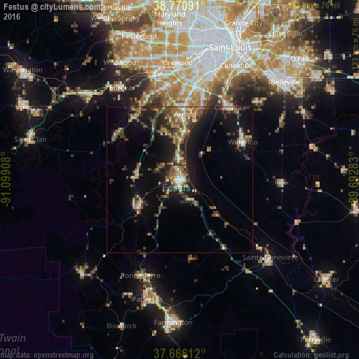
Analysis of Festus night lights 2016
Square area 10x10 km:
 4.93%
4.93%90-99
8.33%80-89
7.65%70-79
4.25%60-69
5.78%50-59
10.71%40-49
6.12%30-39
9.01%20-29
18.03%10-19
23.98%0-9
1.19%Square area 50x50 km:
0.76%90-99
1.17%80-89
1.73%70-79
1.46%60-69
1.92%50-59
2.88%40-49
2.29%30-39
3.49%20-29
4.32%10-19
10.06%0-9
69.92%Clear (daylight) street map image can be seen on geolist.org.
Map coordinates:
38° 46' 15.3" North, 91° 5' 56.7" West
38° 13' 14.2" North, 90° 23' 45.4" West
37° 39' 58" North, 89° 41' 34.2" West
Some cities around Festus sort by population:
• Oakville
28.9 km =18 mi,  16°
16°
• Arnold
23.7 km =14.7 mi,  3°
3°
• Waterloo
25 km =15.5 mi,  59°
59°
• Columbia
30.1 km =18.7 mi,  34°
34°
• Murphy
31 km =19.3 mi,  345°
345°
• De Soto
16.6 km =10.3 mi,  237°
237°
• Barnhart
13.7 km =8.5 mi, 0°
• Pevely
7 km =4.3 mi, 0°
4386419 (p: 12,065)
Sources (retrieved 2019-11-25):
» Earth at Night: Flat Maps 2012, 2016