De Soto night lights from space
Night Light of De Soto (Missouri) from space (United States) Src. Average luminocity for 10x10km area is 18.9031% and for 50x50km: 8.2836%.
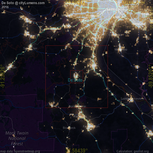
Analysis of De Soto night lights 2016
Square area 10x10 km:
 0.68%
0.68%90-99
2.04%80-89
3.4%70-79
2.72%60-69
2.04%50-59
2.72%40-49
1.7%30-39
5.1%20-29
4.08%10-19
10.88%0-9
64.63%Square area 50x50 km:
0.42%90-99
0.66%80-89
1.04%70-79
0.88%60-69
1.03%50-59
1.81%40-49
1.35%30-39
2.46%20-29
2.65%10-19
5.91%0-9
81.78%Clear (daylight) street map image can be seen on geolist.org.
Map coordinates:
38° 41' 25.5" North, 91° 15' 29.7" West
38° 8' 22.2" North, 90° 33' 18.5" West
37° 35' 3.8" North, 89° 51' 7.2" West
Some cities around De Soto sort by population:
• Arnold
36.1 km =22.4 mi,  25°
25°
• Festus
16.6 km =10.3 mi,  57°
57°
• Park Hills
31.9 km =19.8 mi,  174°
174°
• Murphy
39.5 km =24.5 mi,  8°
8°
• Bonne Terre
24.1 km =15 mi,  180°
180°
• Barnhart
26.8 km =16.7 mi, 31°
• Pevely
21.2 km =13.2 mi,  41°
41°
• Flat River
32.4 km =20.1 mi, 174°
4383513 (p: 6,495)
Sources (retrieved 2019-11-25):
» Earth at Night: Flat Maps 2012, 2016