Fairview Park night lights from space
Night Light of Fairview Park (Ohio) from space (United States) Src. Average luminocity for 10x10km area is 93.3027% and for 50x50km: 46.364%.
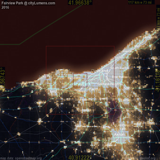
Analysis of Fairview Park night lights 2016
Square area 10x10 km:
 42.01%
90-99
30.61%80-89
13.78%70-79
11.39%60-69
2.21%50-59
0%40-49
0%30-39
0%20-29
0%10-19
0%0-9
0%Square area 50x50 km:
14.3%90-99
9.99%80-89
4.7%70-79
5.19%60-69
8.57%50-59
4.95%40-49
3.79%30-39
4.09%20-29
7.07%10-19
7.96%0-9
29.41%Clear (daylight) street map image can be seen on geolist.org.
Map coordinates:
41° 57' 59" North, 82° 34' 2.7" West
41° 26' 29.2" North, 81° 51' 51.5" West
40° 54' 44" North, 81° 9' 40.2" West
Some cities around Fairview Park sort by population:
• Lakewood
7.1 km =4.4 mi,  50°
50°
• Westlake
4.7 km =2.9 mi,  289°
289°
• North Olmsted
5.7 km =3.5 mi,  239°
239°
• Rocky River
4.3 km =2.7 mi,  28°
28°
• Berea
8.4 km =5.2 mi,  174°
174°
• Brook Park
6.9 km =4.3 mi,  133°
133°
• Bay Village
6.8 km =4.2 mi,  315°
315°
• Olmsted Falls
8.2 km =5.1 mi,  206°
206°
5153680 (p: 16,407)
Sources (retrieved 2019-11-25):
» Earth at Night: Flat Maps 2012, 2016