Escalon night lights from space
Night Light of Escalon (California) from space (United States) Src. Average luminocity for 10x10km area is 18.0204% and for 50x50km: 22.0671%.
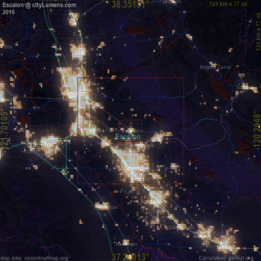
Analysis of Escalon night lights 2016
Square area 10x10 km:
 0.85%
0.85%90-99
1.19%80-89
0%70-79
3.57%60-69
2.38%50-59
2.21%40-49
3.06%30-39
4.08%20-29
4.42%10-19
34.18%0-9
44.05%Square area 50x50 km:
3.62%90-99
3.93%80-89
1.82%70-79
3.65%60-69
3.08%50-59
3.05%40-49
3.76%30-39
4.09%20-29
5.32%10-19
10.73%0-9
56.95%Clear (daylight) street map image can be seen on geolist.org.
Map coordinates:
38° 21' 4.7" North, 121° 42' 3.8" West
37° 47' 52.1" North, 120° 59' 52.5" West
37° 14' 24.5" North, 120° 17' 41.3" West
Some cities around Escalon sort by population:
• Modesto
17.6 km =10.9 mi,  179°
179°
• Manteca
19.2 km =11.9 mi,  269°
269°
• Riverbank
8.8 km =5.5 mi,  141°
141°
• Oakdale
13.7 km =8.5 mi,  104°
104°
• Ripon
12.8 km =8 mi,  240°
240°
• Salida
12.8 km =8 mi,  216°
216°
• West Modesto
20.4 km =12.7 mi,  190°
190°
• Bret Harte
21.8 km =13.5 mi, 181°
5346811 (p: 7,523)
Sources (retrieved 2019-11-25):
» Earth at Night: Flat Maps 2012, 2016