Eldorado at Santa Fe night lights from space
Night Light of Eldorado at Santa Fe (New Mexico) from space (United States) Src. Average luminocity for 10x10km area is 0.5092% and for 50x50km: 5.1249%.
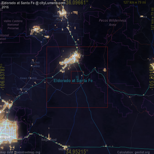
Analysis of Eldorado at Santa Fe night lights 2016
Square area 10x10 km:
 0%
0%90-99
0%80-89
0%70-79
0%60-69
0%50-59
0.73%40-49
0%30-39
0%20-29
0%10-19
0%0-9
99.27%Square area 50x50 km:
0.54%90-99
0.69%80-89
0.51%70-79
1.24%60-69
0.88%50-59
0.42%40-49
0.56%30-39
0.71%20-29
1.74%10-19
3.66%0-9
89.05%Clear (daylight) street map image can be seen on geolist.org.
Map coordinates:
36° 5' 47.8" North, 106° 38' 16.3" West
35° 31' 35.1" North, 105° 56' 5.1" West
34° 57' 7.7" North, 105° 13' 53.8" West
Some cities around Eldorado at Santa Fe sort by population:
• Enchanted Hills
63.3 km =39.3 mi,  250°
250°
• Santa Fe
17.9 km =11.1 mi,  359°
359°
• Las Vegas
64.7 km =40.2 mi,  83°
83°
• Los Alamos
52.4 km =32.6 mi,  320°
320°
• Española
53.3 km =33.1 mi,  345°
345°
• Bernalillo
61.3 km =38.1 mi, 245°
• Corrales
68.8 km =42.8 mi,  242°
242°
• White Rock
41.4 km =25.7 mi, 324°
5466585 (p: 6,130)
Sources (retrieved 2019-11-25):
» Earth at Night: Flat Maps 2012, 2016