East Lake night lights from space
Night Light of East Lake (Florida) from space (United States) Src. Average luminocity for 10x10km area is 73.5133% and for 50x50km: 50.9766%.

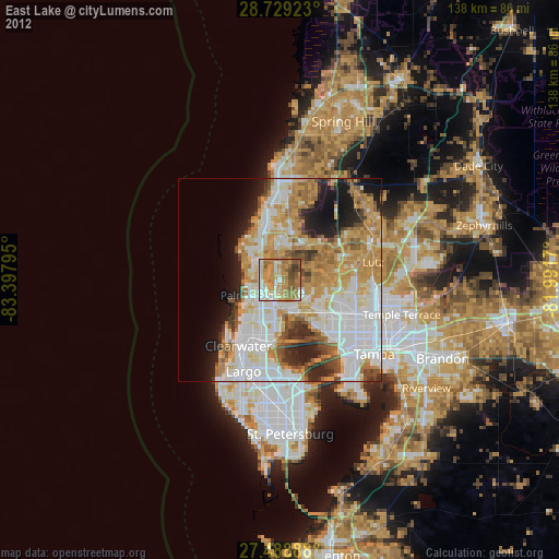
Analysis of East Lake night lights 2016
Square area 10x10 km:
 8.33%
8.33%90-99
13.26%80-89
12.88%70-79
18.37%60-69
30.3%50-59
9.28%40-49
7.58%30-39
0%20-29
0%10-19
0%0-9
0%Square area 50x50 km:
14.08%90-99
11.16%80-89
5.33%70-79
7.1%60-69
12.02%50-59
4.86%40-49
4.04%30-39
3.5%20-29
6.7%10-19
6.88%0-9
24.33%Clear (daylight) street map image can be seen on geolist.org.
Map coordinates:
28° 43' 45.2" North, 83° 23' 52.6" West
28° 6' 39.1" North, 82° 41' 41.4" West
27° 29' 20" North, 81° 59' 30.1" West
Some cities around East Lake sort by population:
• Palm Harbor
7.7 km =4.8 mi,  241°
241°
• Tarpon Springs
7.2 km =4.5 mi,  302°
302°
• Keystone
8.8 km =5.5 mi,  55°
55°
• Holiday
9.6 km =6 mi,  332°
332°
• Westchase
10.4 km =6.5 mi,  126°
126°
• Oldsmar
9 km =5.6 mi,  161°
161°
• Elfers
12.1 km =7.5 mi,  347°
347°
• Trinity
7.9 km =4.9 mi,  9°
9°
4154008 (p: 30,962)
Sources (retrieved 2019-11-25):
» Earth at Night: Flat Maps 2012, 2016