Dunkirk night lights from space
Night Light of Dunkirk (New York) from space (United States) Src. Average luminocity for 10x10km area is 31.2667% and for 50x50km: 3.2529%.
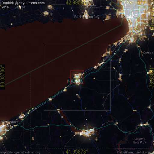
Analysis of Dunkirk night lights 2016
Square area 10x10 km:
 3.02%
3.02%90-99
6.19%80-89
4.92%70-79
4.76%60-69
2.38%50-59
4.44%40-49
6.83%30-39
2.38%20-29
2.7%10-19
32.38%0-9
30%Square area 50x50 km:
0.12%90-99
0.51%80-89
0.38%70-79
0.64%60-69
0.27%50-59
0.44%40-49
0.73%30-39
0.44%20-29
0.55%10-19
1.86%0-9
94.07%Clear (daylight) street map image can be seen on geolist.org.
Map coordinates:
42° 59' 45.3" North, 80° 2' 13.4" West
42° 28' 46.2" North, 79° 20' 2.1" West
41° 57' 31.6" North, 78° 37' 50.9" West
Some cities around Dunkirk sort by population:
• Thunder Bay, CA
50.8 km =31.6 mi,  28°
28°
• Welland, CA
56.5 km =35.1 mi,  7°
7°
• Jamestown
43.3 km =26.9 mi,  169°
169°
• Port Colborne, CA
47.5 km =29.5 mi, 10°
• Lackawanna
56.8 km =35.3 mi,  47°
47°
• Fredonia
4.4 km =2.7 mi,  177°
177°
• Hamburg
48.9 km =30.4 mi,  57°
57°
• Boston
51.6 km =32.1 mi,  71°
71°
5115495 (p: 12,081)
Sources (retrieved 2019-11-25):
» Earth at Night: Flat Maps 2012, 2016