Dranesville night lights from space
Night Light of Dranesville (Virginia) from space (United States) Src. Average luminocity for 10x10km area is 72.3766% and for 50x50km: 61.9604%.
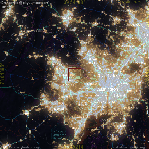
Analysis of Dranesville night lights 2016
Square area 10x10 km:
 11.36%
90-99
11.85%80-89
9.09%70-79
23.05%60-69
14.45%50-59
24.19%40-49
3.41%30-39
0.65%20-29
1.95%10-19
0%0-9
0%Square area 50x50 km:
15.23%90-99
14.44%80-89
8.54%70-79
11.02%60-69
10.91%50-59
7.28%40-49
4.47%30-39
4.72%20-29
5.74%10-19
6.55%0-9
11.08%Clear (daylight) street map image can be seen on geolist.org.
Map coordinates:
39° 32' 41.9" North, 78° 2' 56.2" West
39° 0' 2.4" North, 77° 20' 45" West
38° 27' 7.7" North, 76° 38' 33.7" West
Some cities around Dranesville sort by population:
• Reston
3.6 km =2.2 mi,  173°
173°
• Sterling
7.2 km =4.5 mi,  274°
274°
• Herndon
4.9 km =3 mi,  225°
225°
• Wolf Trap
8.5 km =5.3 mi,  142°
142°
• Great Falls
5 km =3.1 mi,  93°
93°
• Sugarland Run
4.8 km =3 mi,  328°
328°
• Lowes Island
6.6 km =4.1 mi,  355°
355°
• Countryside
7.4 km =4.6 mi,  307°
307°
4756348 (p: 11,921)
Sources (retrieved 2019-11-25):
» Earth at Night: Flat Maps 2012, 2016