Prairieville night lights from space
Night Light of Prairieville (Louisiana) from space (United States) Src. Average luminocity for 10x10km area is 76.848% and for 50x50km: 52.2657%.

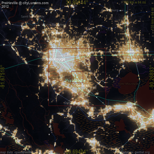
Analysis of Prairieville night lights 2016
Square area 10x10 km:
 9.34%
9.34%90-99
12.64%80-89
23.26%70-79
25.09%60-69
14.65%50-59
8.97%40-49
5.86%30-39
0.18%20-29
0%10-19
0%0-9
0%Square area 50x50 km:
10.71%90-99
7.81%80-89
9.72%70-79
9.26%60-69
10.09%50-59
6.16%40-49
8.56%30-39
5.43%20-29
5.46%10-19
9.63%0-9
17.16%Clear (daylight) street map image can be seen on geolist.org.
Map coordinates:
30° 54' 29.3" North, 91° 40' 30.6" West
30° 18' 10.7" North, 90° 58' 19.4" West
29° 41' 38.5" North, 90° 16' 8.1" West
Some cities around Prairieville sort by population:
• Shenandoah
11.3 km =7 mi,  345°
345°
• Gonzales
8.7 km =5.4 mi,  145°
145°
• Gardere
16.8 km =10.4 mi,  286°
286°
• Oak Hills Place
12.8 km =8 mi,  299°
299°
• Village Saint George
11.3 km =7 mi,  305°
305°
• Old Jefferson
9.9 km =6.2 mi,  334°
334°
• Saint Gabriel
13.2 km =8.2 mi,  247°
247°
• Inniswold
15.6 km =9.7 mi,  316°
316°
4338012 (p: 26,895)
Sources (retrieved 2019-11-25):
» Earth at Night: Flat Maps 2012, 2016