Gladstone night lights from space
Night Light of Gladstone (Oregon) from space (United States) Src. Average luminocity for 10x10km area is 63.8984% and for 50x50km: 37.0651%.
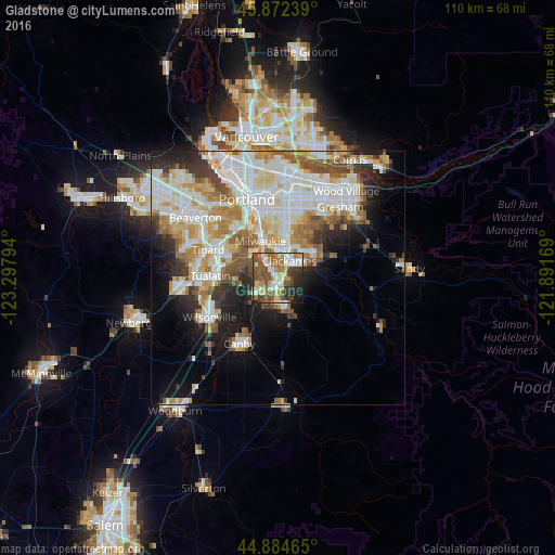
Analysis of Gladstone night lights 2016
Square area 10x10 km:
 12.38%
90-99
10.79%80-89
8.25%70-79
10.32%60-69
13.02%50-59
16.35%40-49
7.46%30-39
7.14%20-29
9.68%10-19
4.6%0-9
0%Square area 50x50 km:
9.9%90-99
9.87%80-89
4.07%70-79
4.69%60-69
4.53%50-59
4.11%40-49
3.22%30-39
2.99%20-29
4.72%10-19
8.46%0-9
43.45%Clear (daylight) street map image can be seen on geolist.org.
Map coordinates:
45° 52' 20.6" North, 123° 17' 52.6" West
45° 22' 50.4" North, 122° 35' 41.3" West
44° 53' 4.7" North, 121° 53' 30.1" West
Some cities around Gladstone sort by population:
• Lake Oswego
7.4 km =4.6 mi,  306°
306°
• Oregon City
2.8 km =1.7 mi,  199°
199°
• West Linn
2.2 km =1.4 mi,  219°
219°
• Milwaukie
8.1 km =5 mi,  334°
334°
• Oak Grove
5.3 km =3.3 mi,  318°
318°
• Oatfield
3.7 km =2.3 mi,  353°
353°
• Jennings Lodge
1.8 km =1.1 mi, 310°
• Clackamas
3.6 km =2.2 mi,  32°
32°
5728429 (p: 11,986)
Sources (retrieved 2019-11-25):
» Earth at Night: Flat Maps 2012, 2016