Clackamas night lights from space
Night Light of Clackamas (Oregon) from space (United States) Src. Average luminocity for 10x10km area is 71.1508% and for 50x50km: 39.2583%.
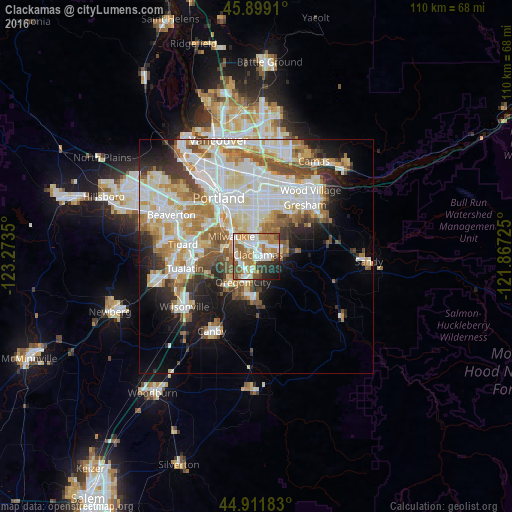
Analysis of Clackamas night lights 2016
Square area 10x10 km:
 19.37%
90-99
16.83%80-89
5.87%70-79
12.06%60-69
17.78%50-59
7.46%40-49
3.49%30-39
5.56%20-29
7.78%10-19
3.81%0-9
0%Square area 50x50 km:
10.33%90-99
10.56%80-89
4.47%70-79
5.06%60-69
4.92%50-59
4.48%40-49
3.42%30-39
2.96%20-29
4.74%10-19
8.57%0-9
40.51%Clear (daylight) street map image can be seen on geolist.org.
Map coordinates:
45° 53' 56.8" North, 123° 16' 24.6" West
45° 24' 27.4" North, 122° 34' 13.3" West
44° 54' 42.6" North, 121° 52' 2.1" West
Some cities around Clackamas sort by population:
• Oregon City
6.3 km =3.9 mi,  206°
206°
• West Linn
5.7 km =3.5 mi,  215°
215°
• Milwaukie
6.9 km =4.3 mi,  308°
308°
• Happy Valley
5.4 km =3.4 mi,  35°
35°
• Oak Grove
5.5 km =3.4 mi,  280°
280°
• Oatfield
2.4 km =1.5 mi,  287°
287°
• Gladstone
3.6 km =2.2 mi, 212°
• Jennings Lodge
3.8 km =2.4 mi,  241°
241°
5719308 (p: 6,767)
Sources (retrieved 2019-11-25):
» Earth at Night: Flat Maps 2012, 2016