Cutlerville night lights from space
Night Light of Cutlerville (Michigan) from space (United States) Src. Average luminocity for 10x10km area is 67.9% and for 50x50km: 22.9747%.
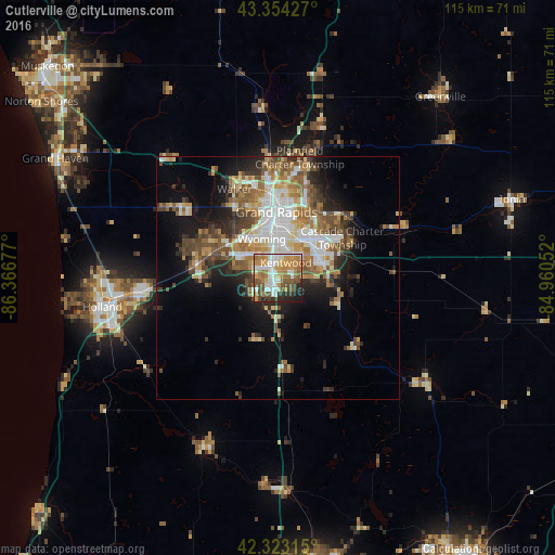
Analysis of Cutlerville night lights 2016
Square area 10x10 km:
 14.29%
90-99
15.24%80-89
5.71%70-79
13.17%60-69
15.87%50-59
10.79%40-49
9.05%30-39
4.6%20-29
7.46%10-19
3.81%0-9
0%Square area 50x50 km:
4.28%90-99
3.97%80-89
2.62%70-79
2.76%60-69
4.17%50-59
3.68%40-49
3.9%30-39
2.88%20-29
4.23%10-19
8.44%0-9
59.07%Clear (daylight) street map image can be seen on geolist.org.
Map coordinates:
43° 21' 15.4" North, 86° 22' 0.4" West
42° 50' 27.1" North, 85° 39' 49.1" West
42° 19' 23.3" North, 84° 57' 37.9" West
Some cities around Cutlerville sort by population:
• Grand Rapids
13.6 km =8.5 mi,  358°
358°
• Wyoming
8.7 km =5.4 mi,  337°
337°
• Kentwood
3.5 km =2.2 mi,  25°
25°
• Jenison
12.8 km =8 mi,  305°
305°
• Grandville
11.2 km =7 mi, 313°
• East Grand Rapids
12 km =7.5 mi,  21°
21°
• Hudsonville
16.8 km =10.4 mi,  281°
281°
• Byron Center
5.8 km =3.6 mi,  236°
236°
4990242 (p: 14,370)
Sources (retrieved 2019-11-25):
» Earth at Night: Flat Maps 2012, 2016