Auburndale night lights from space
Night Light of Auburndale (Florida) from space (United States) Src. Average luminocity for 10x10km area is 68.2027% and for 50x50km: 44.2565%.
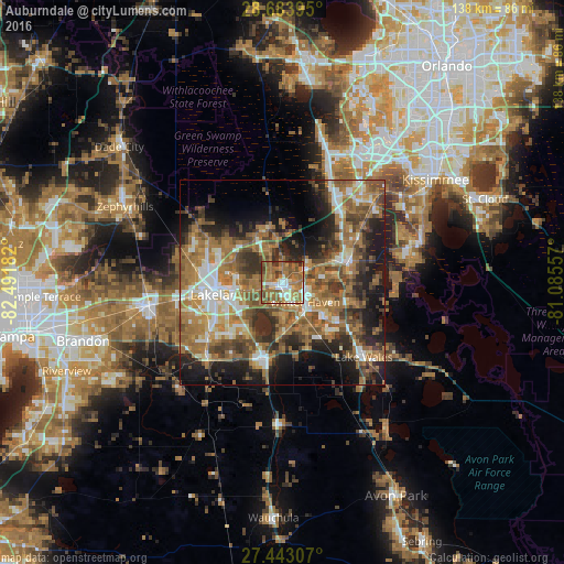
Analysis of Auburndale night lights 2016
Square area 10x10 km:
 8.14%
8.14%90-99
11.36%80-89
5.3%70-79
10.04%60-69
34.85%50-59
17.99%40-49
7.39%30-39
3.22%20-29
1.7%10-19
0%0-9
0%Square area 50x50 km:
5.04%90-99
6.28%80-89
3.48%70-79
5.19%60-69
17.13%50-59
8.52%40-49
7.83%30-39
7.43%20-29
9.31%10-19
12.98%0-9
16.81%Clear (daylight) street map image can be seen on geolist.org.
Map coordinates:
28° 41' 2.2" North, 82° 29' 30.6" West
28° 3' 55.1" North, 81° 47' 19.3" West
27° 26' 35.1" North, 81° 5' 8.1" West
Some cities around Auburndale sort by population:
• Winter Haven
7.3 km =4.5 mi,  131°
131°
• Cypress Gardens
12.5 km =7.8 mi, 129°
• Inwood
3.9 km =2.4 mi,  143°
143°
• Combee Settlement
11.5 km =7.1 mi,  266°
266°
• Jan-Phyl Village
5.9 km =3.7 mi,  163°
163°
• Fussels Corner
7.2 km =4.5 mi,  260°
260°
• Crystal Lake
12.2 km =7.6 mi,  254°
254°
• Lake Alfred
7.1 km =4.4 mi,  65°
65°
4146389 (p: 15,035)
Sources (retrieved 2019-11-25):
» Earth at Night: Flat Maps 2012, 2016