South Patrick Shores night lights from space
Night Light of South Patrick Shores (Florida) from space (United States) Src. Average luminocity for 10x10km area is 35.3413% and for 50x50km: 22.6142%.
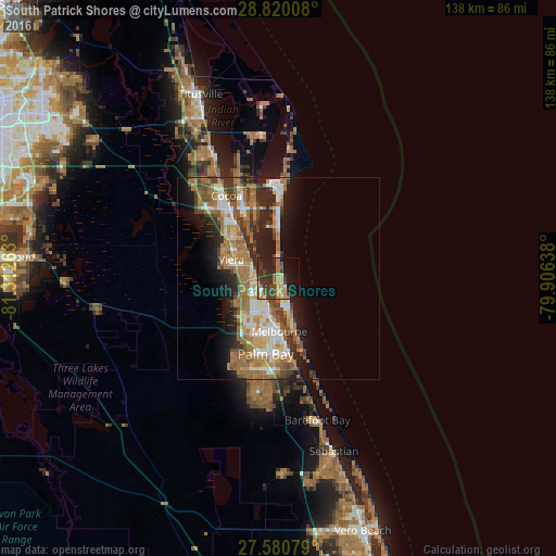
Analysis of South Patrick Shores night lights 2016
Square area 10x10 km:
 0.6%
0.6%90-99
1.79%80-89
4.17%70-79
9.33%60-69
6.15%50-59
3.97%40-49
7.34%30-39
14.88%20-29
16.87%10-19
23.41%0-9
11.51%Square area 50x50 km:
2.8%90-99
3.47%80-89
2.01%70-79
3.09%60-69
7.51%50-59
3.69%40-49
3.16%30-39
3.3%20-29
5.45%10-19
8.6%0-9
56.92%Clear (daylight) street map image can be seen on geolist.org.
Map coordinates:
28° 49' 12.3" North, 81° 18' 45.5" West
28° 12' 8" North, 80° 36' 34.2" West
27° 34' 50.8" North, 79° 54' 23" West
Some cities around South Patrick Shores sort by population:
• Palm Bay
18.8 km =11.7 mi,  173°
173°
• Melbourne
13.2 km =8.2 mi,  179°
179°
• West Melbourne
15.1 km =9.4 mi,  196°
196°
• Cocoa Beach
13.2 km =8.2 mi,  0°
0°
• Viera East
12.3 km =7.6 mi,  303°
303°
• Satellite Beach
3.5 km =2.2 mi,  146°
146°
• Indian Harbour Beach
6.3 km =3.9 mi,  160°
160°
• Viera West
13.1 km =8.1 mi,  291°
291°
4173528 (p: 5,875)
Sources (retrieved 2019-11-25):
» Earth at Night: Flat Maps 2012, 2016