Clinton night lights from space
Night Light of Clinton (Oklahoma) from space (United States) Src. Average luminocity for 10x10km area is 28.3645% and for 50x50km: 2.7971%.
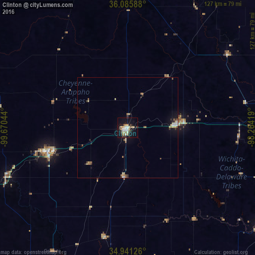
Analysis of Clinton night lights 2016
Square area 10x10 km:
 4.95%
4.95%90-99
3.11%80-89
5.86%70-79
2.56%60-69
3.85%50-59
1.83%40-49
2.56%30-39
5.86%20-29
1.65%10-19
32.78%0-9
34.98%Square area 50x50 km:
0.28%90-99
0.27%80-89
0.6%70-79
0.19%60-69
0.54%50-59
0.33%40-49
0.13%30-39
0.67%20-29
0.26%10-19
2.18%0-9
94.54%Clear (daylight) street map image can be seen on geolist.org.
Map coordinates:
36° 5' 9.2" North, 99° 40' 13.6" West
35° 30' 56.2" North, 98° 58' 2.3" West
34° 56' 28.5" North, 98° 15' 51.1" West
Some cities around Clinton sort by population:
• Altus
103.1 km =64.1 mi,  198°
198°
• El Reno
91.6 km =56.9 mi,  88°
88°
• Chickasha
106.8 km =66.4 mi,  118°
118°
• Woodward
108.9 km =67.7 mi,  339°
339°
• Elk City
41.2 km =25.6 mi,  253°
253°
• Weatherford
23.5 km =14.6 mi, 87°
• Tuttle
107.6 km =66.9 mi,  103°
103°
• Anadarko
82.1 km =51 mi,  126°
126°
4533738 (p: 9,565)
Sources (retrieved 2019-11-25):
» Earth at Night: Flat Maps 2012, 2016