Citrus Ridge night lights from space
Night Light of Citrus Ridge (Florida) from space (United States) Src. Average luminocity for 10x10km area is 76.623% and for 50x50km: 48.8577%.
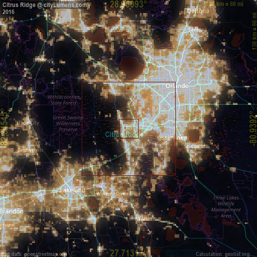
Analysis of Citrus Ridge night lights 2016
Square area 10x10 km:
 16.87%
90-99
21.03%80-89
7.54%70-79
9.92%60-69
22.02%50-59
16.47%40-49
2.18%30-39
2.18%20-29
1.79%10-19
0%0-9
0%Square area 50x50 km:
11.94%90-99
11.09%80-89
4.76%70-79
6.57%60-69
10.52%50-59
5.91%40-49
4.66%30-39
4.46%20-29
7.35%10-19
9.36%0-9
23.4%Clear (daylight) street map image can be seen on geolist.org.
Map coordinates:
28° 57' 3.3" North, 82° 20' 43.6" West
28° 20' 1.9" North, 81° 38' 32.4" West
27° 42' 47.4" North, 80° 56' 21.1" West
Some cities around Citrus Ridge sort by population:
• Kissimmee
22.3 km =13.9 mi,  98°
98°
• Four Corners
0.5 km =0.3 mi,  257°
257°
• Lake Butler
21.1 km =13.1 mi,  27°
27°
• Hunters Creek
21.7 km =13.5 mi,  82°
82°
• Horizon West
11.3 km =7 mi,  9°
9°
• Doctor Phillips
19.5 km =12.1 mi,  48°
48°
• Williamsburg
21.5 km =13.4 mi,  65°
65°
• Celebration
10.7 km =6.6 mi, 95°
4151162 (p: 13,285)
Sources (retrieved 2019-11-25):
» Earth at Night: Flat Maps 2012, 2016