Collingswood night lights from space
Night Light of Collingswood (New Jersey) from space (United States) Src. Average luminocity for 10x10km area is 97.267% and for 50x50km: 76.4303%.
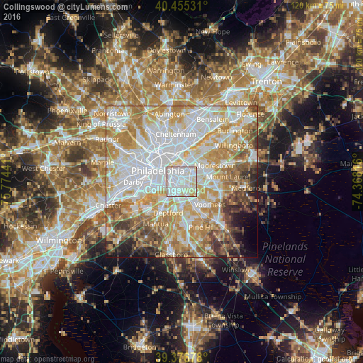
Analysis of Collingswood night lights 2016
Square area 10x10 km:
 50%
50%90-99
40.99%80-89
8.33%70-79
0.68%60-69
0%50-59
0%40-49
0%30-39
0%20-29
0%10-19
0%0-9
0%Square area 50x50 km:
25.32%90-99
18.17%80-89
10.64%70-79
13.03%60-69
10.58%50-59
5.85%40-49
5.21%30-39
3.68%20-29
2.4%10-19
2.82%0-9
2.28%Clear (daylight) street map image can be seen on geolist.org.
Map coordinates:
40° 27' 19.1" North, 75° 46' 27.9" West
39° 55' 5.4" North, 75° 4' 16.6" West
39° 22' 36.4" North, 74° 22' 5.4" West
Some cities around Collingswood sort by population:
• Camden
4.2 km =2.6 mi,  281°
281°
• Cherry Hill
3.9 km =2.4 mi,  61°
61°
• Pennsauken
4.4 km =2.7 mi,  15°
15°
• Cherry Hill Mall
5.7 km =3.5 mi,  69°
69°
• Haddonfield
4.1 km =2.5 mi,  135°
135°
• Gloucester City
4.8 km =3 mi,  232°
232°
• Audubon
3 km =1.9 mi,  182°
182°
• Haddon Heights
4.6 km =2.9 mi,  172°
172°
4501306 (p: 14,000)
Sources (retrieved 2019-11-25):
» Earth at Night: Flat Maps 2012, 2016