Carlstadt night lights from space
Night Light of Carlstadt (New Jersey) from space (United States) Src. Average luminocity for 10x10km area is 98.9966% and for 50x50km: 85.3984%.
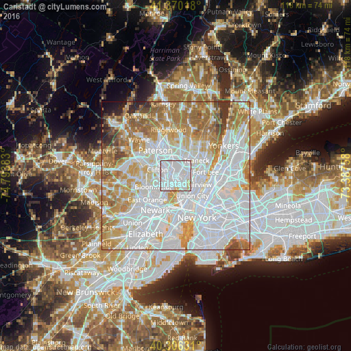
Analysis of Carlstadt night lights 2016
Square area 10x10 km:
 77.38%
90-99
18.2%80-89
4.42%70-79
0%60-69
0%50-59
0%40-49
0%30-39
0%20-29
0%10-19
0%0-9
0%Square area 50x50 km:
40.96%90-99
18.78%80-89
7.96%70-79
10.53%60-69
10.73%50-59
4.92%40-49
2.15%30-39
1.84%20-29
1.18%10-19
0.8%0-9
0.16%Clear (daylight) street map image can be seen on geolist.org.
Map coordinates:
41° 22' 12.6" North, 74° 47' 37.8" West
40° 50' 25.4" North, 74° 5' 26.5" West
40° 18' 22.7" North, 73° 23' 15.3" West
Some cities around Carlstadt sort by population:
• Passaic
3.7 km =2.3 mi,  299°
299°
• Lyndhurst
4.2 km =2.6 mi,  221°
221°
• Rutherford
2.1 km =1.3 mi, 221°
• Hasbrouck Heights
2.1 km =1.3 mi,  23°
23°
• Wallington
2.4 km =1.5 mi,  306°
306°
• Little Ferry
4.3 km =2.7 mi,  71°
71°
• East Rutherford
0.9 km =0.6 mi, 217°
• Wood-Ridge
0.6 km =0.4 mi, 21°
5096289 (p: 6,279)
Sources (retrieved 2019-11-25):
» Earth at Night: Flat Maps 2012, 2016