Camp Pendleton South night lights from space
Night Light of Camp Pendleton South (California) from space (United States) Src. Average luminocity for 10x10km area is 44.3916% and for 50x50km: 20.682%.
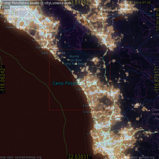
Analysis of Camp Pendleton South night lights 2016
Square area 10x10 km:
 5.77%
5.77%90-99
8.22%80-89
3.85%70-79
1.92%60-69
12.59%50-59
8.74%40-49
7.34%30-39
5.94%20-29
16.08%10-19
25.17%0-9
4.37%Square area 50x50 km:
2.04%90-99
2.32%80-89
1.13%70-79
1.5%60-69
7.17%50-59
5.9%40-49
4.21%30-39
3.31%20-29
5.64%10-19
9.09%0-9
57.67%Clear (daylight) street map image can be seen on geolist.org.
Map coordinates:
33° 48' 52.6" North, 118° 4' 56.7" West
33° 13' 42.4" North, 117° 22' 45.4" West
32° 38' 17.9" North, 116° 40' 34.2" West
Some cities around Camp Pendleton South sort by population:
• Oceanside
3.6 km =2.2 mi,  180°
180°
• Escondido
29.8 km =18.5 mi,  114°
114°
• Carlsbad
8.3 km =5.2 mi,  161°
161°
• Vista
13.1 km =8.1 mi,  103°
103°
• San Marcos
22 km =13.7 mi,  115°
115°
• Encinitas
22.8 km =14.2 mi, 159°
• Fallbrook
20.3 km =12.6 mi,  35°
35°
• Solana Beach
28.2 km =17.5 mi, 159°
7260997 (p: 10,616)
Sources (retrieved 2019-11-25):
» Earth at Night: Flat Maps 2012, 2016