Camp Pendleton North night lights from space
Night Light of Camp Pendleton North (California) from space (United States) Src. Average luminocity for 10x10km area is 29.3112% and for 50x50km: 22.2076%.
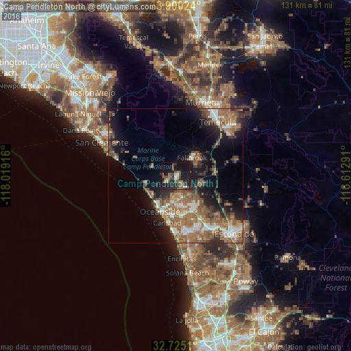
Analysis of Camp Pendleton North night lights 2016
Square area 10x10 km:
 1.05%
1.05%90-99
2.45%80-89
1.92%70-79
1.05%60-69
7.87%50-59
7.87%40-49
7.34%30-39
5.94%20-29
13.46%10-19
34.62%0-9
16.43%Square area 50x50 km:
2.64%90-99
2.9%80-89
1.15%70-79
1.84%60-69
7.09%50-59
5.96%40-49
3.77%30-39
3.77%20-29
4.95%10-19
10.63%0-9
55.31%Clear (daylight) street map image can be seen on geolist.org.
Map coordinates:
33° 54' 0.9" North, 118° 1' 9" West
33° 18' 52.7" North, 117° 18' 57.7" West
32° 43' 30.4" North, 116° 36' 46.5" West
Some cities around Camp Pendleton North sort by population:
• Oceanside
14.5 km =9 mi,  204°
204°
• Carlsbad
17.7 km =11 mi,  190°
190°
• Temecula
25.3 km =15.7 mi,  38°
38°
• Murrieta
28.2 km =17.5 mi,  19°
19°
• Vista
14.5 km =9 mi,  151°
151°
• San Marcos
23.6 km =14.7 mi,  143°
143°
• Fallbrook
9.1 km =5.7 mi, 41°
• Valley Center
28.3 km =17.6 mi,  112°
112°
7260996 (p: 5,200)
Sources (retrieved 2019-11-25):
» Earth at Night: Flat Maps 2012, 2016