Malvern night lights from space
Night Light of Malvern (Arkansas) from space (United States) Src. Average luminocity for 10x10km area is 32.3535% and for 50x50km: 9.0765%.
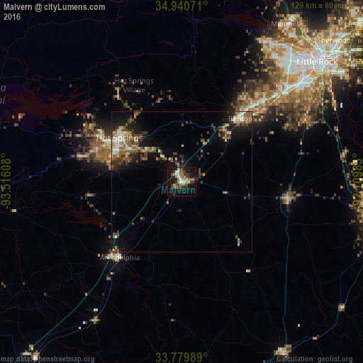
Analysis of Malvern night lights 2016
Square area 10x10 km:
 2.38%
2.38%90-99
5.31%80-89
4.21%70-79
1.83%60-69
6.41%50-59
7.69%40-49
3.11%30-39
10.81%20-29
2.38%10-19
34.25%0-9
21.61%Square area 50x50 km:
0.8%90-99
1.02%80-89
1.05%70-79
0.85%60-69
1.32%50-59
2.15%40-49
1.46%30-39
2.28%20-29
2.2%10-19
6.55%0-9
80.33%Clear (daylight) street map image can be seen on geolist.org.
Map coordinates:
34° 56' 26.6" North, 93° 30' 57.9" West
34° 21' 44.3" North, 92° 48' 46.6" West
33° 46' 47.6" North, 92° 6' 35.4" West
Some cities around Malvern sort by population:
• Little Rock
64.2 km =39.9 mi,  48°
48°
• Hot Springs
27.2 km =16.9 mi,  305°
305°
• Hot Springs National Park
29.7 km =18.5 mi, 309°
• Benton
30.6 km =19 mi,  42°
42°
• Bryant
39.4 km =24.5 mi, 48°
• Hot Springs Village
38.4 km =23.9 mi,  333°
333°
• Arkadelphia
34.8 km =21.6 mi,  219°
219°
• East End
48.1 km =29.9 mi,  64°
64°
4120388 (p: 10,928)
Sources (retrieved 2019-11-25):
» Earth at Night: Flat Maps 2012, 2016