Okolona night lights from space
Night Light of Okolona (Kentucky) from space (United States) Src. Average luminocity for 10x10km area is 92.9881% and for 50x50km: 46.8471%.
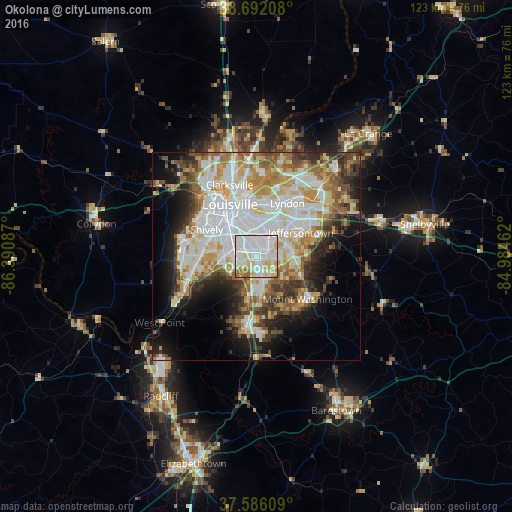
Analysis of Okolona night lights 2016
Square area 10x10 km:
 43.03%
90-99
29.93%80-89
14.29%70-79
6.63%60-69
4.25%50-59
1.87%40-49
0%30-39
0%20-29
0%10-19
0%0-9
0%Square area 50x50 km:
12.85%90-99
11.02%80-89
6.18%70-79
5.74%60-69
5.76%50-59
4.92%40-49
4.67%30-39
5.05%20-29
6.42%10-19
9.55%0-9
27.83%Clear (daylight) street map image can be seen on geolist.org.
Map coordinates:
38° 41' 31.5" North, 86° 23' 27.1" West
38° 8' 28.2" North, 85° 41' 15.9" West
37° 35' 9.9" North, 84° 59' 4.6" West
Some cities around Okolona sort by population:
• Jeffersontown
12.3 km =7.6 mi,  61°
61°
• Newburg
3.2 km =2 mi,  49°
49°
• Fern Creek
9 km =5.6 mi,  76°
76°
• Saint Matthews
12.7 km =7.9 mi,  12°
12°
• Highview
5.6 km =3.5 mi,  88°
88°
• Fairdale
7.4 km =4.6 mi,  237°
237°
• Hillview
7.9 km =4.9 mi,  178°
178°
• Buechel
6.8 km =4.2 mi,  27°
27°
4303012 (p: 17,134)
Sources (retrieved 2019-11-25):
» Earth at Night: Flat Maps 2012, 2016